After the 2010 Census, the Illinois State Legislature was charged with redrawing the boundaries for legislative and representative districts in Illinois. In order to determine your State Senator and State Representative, you will determine which district you are in. Each State Senate District contains two State Representative Districts.
Here are maps of the realigned Illinois Legislative Districts 13-59
You can find maps for Districts 1-12 here.
You can find maps for Districts 1-12 here.
Map of 2012 Illinois Legislative District 13, which includes State Senate District 13 and State Representative Districts 25 and 26:
 |
| Map of realigned Illinois Legislative District 13, consisting of Representative District 25 and 26. |
Map of 2012 Illinois Legislative District 14, which includes State Senate District 14 and State Representative Districts 27 and 28:
 |
| Map of realigned Illinois State Legislative District 14 and State Representative District 27 and 28. |
Map of 2012 Illinois Legislative District 15, which includes State Senate District 15 and State Representative Districts 29 and 30:
 |
| Map of realigned Illinois Legislative District 15, including Representative Districts 29 and 30, including part of eastern Will County and the towns of Monee and Crete. |
Map of 2012 Illinois Legislative District 16, which includes State Senate District 16 and State Representative Districts 31 and 32:
 |
| Map of realigned Illinois Legislative District 16, consisting of Representative Districts 31 and 32. |
Map of 2012 Illinois Legislative District 17, which includes State Senate District 17 and State Representative Districts 33 and 34:
Map of 2012 Illinois Legislative District 18, which includes State Senate District 18 and State Representative Districts 35 and 36:
 |
| Map of realigned Illinois Legislative District 18 and State Representative Districts 35 and 36 |
Map of 2012 Illinois Legislative District 19, which includes State Senate District 19 and State Representative Districts 37 and 38:
 |
| Map of realigned Illinois State Legislative District 19 and State Representative Districts 37 and 38, including the Will County towns of Mokena, New Lenox, Lockport, and Frankfort. |
Map of 2012 Illinois Legislative District 20, which includes State Senate District 20 and State Representative Districts 39 and 40:
 |
| Map of realigned Illinois State Legislative District 20 and State Representative Districts 39 and 40. |
Map of 2012 Illinois Legislative District 21, which includes State Senate District 21 and State Representative Districts 41 and 42:
 |
| Map of realigned Illinois State Legislative District 21 and State Representative Districts 41 and 42. |
Map of 2012 Illinois Legislative District 22, which includes State Senate District 22 and State Representative Districts 43 and 44:
 |
| Map of realigned Illinois State Legislative District 22 and State Representative Districts 43 and 44. |
Map of 2012 Illinois Legislative District 23, which includes State Senate District 23 and State Representative Districts 45 and 46:
 |
| Map of realigned Illinois State Legislative District 23 and State Representative Districts 45 and 46. |
Map of 2012 Illinois Legislative District 24, which includes State Senate District 24 and State Representative Districts 47 and 48:
 |
| Map of realigned Illinois State 24th Legislative District and 47th and 48th State Representative Districts |
Map of 2012 Illinois Legislative District 25, which includes State Senate District 25 and State Representative Districts 49 and 50:
 |
| Map of realigned Illinois State Legislative District 25 and State Representative Districts 49 and 50. |
Map of 2012 Illinois Legislative District 26, which includes State Senate District 26 and State Representative Districts 51 and 52:
 |
| Map of realigned Illinois State 26th Legislative District and Illinois State Representative Districts 51 and 52. |
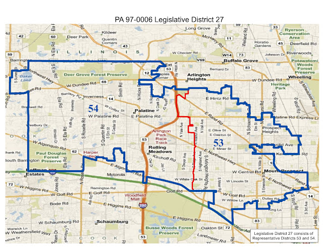
Map of 2012 Illinois Legislative District 27, which includes State Senate District 27 and State Representative Districts 53 and 54:
 |
| Map of realigned Illinois State Legislative District 27 and State Representative Districts 53 and 54. |
Map of 2012 Illinois Legislative District 28, which includes State Senate District 28 and State Representative Districts 55 and 56:
 |
| Map of realigned Illinois State Legislative District 28 and State Representative Districts 55 and 56. |
Map of 2012 Illinois Legislative District 29, which includes State Senate District 29 and State Representative Districts 57 and 58:
 |
| Map of realigned Illinois State Legislative District 29 and State Representative Districts 57 and 58. |
Map of 2012 Illinois Legislative District 30, which includes State Senate District 30 and State Representative Districts 59 and 60:
 |
| Map of realigned Illinois State Legislative District 30, including State Representative District 59 and 60. |
Map of 2012 Illinois Legislative District 31, which includes State Senate District 31 and State Representative Districts 61 and 62:
 |
| Map of realigned Illinois State Legislative District 31 and State Representative Districts 61 and 62. |
Map of 2012 Illinois Legislative District 32, which includes State Senate District 32 and State Representative Districts 63 and 64:
 |
| Map of realigned Illinois State Legislative District 32 and Illinois State Representative Districts 63 and 64. |
Map of 2012 Illinois Legislative District 33, which includes State Senate District 33 and State Representative Districts 65 and 66:
 |
| Map of realigned Illinois State Legislative District 33 and State Representative Districts 65 and 66. |
Map of 2012 Illinois Legislative District 34, which includes State Senate District 34 and State Representative Districts 67 and 68:
 |
| Map of realigned Illinois State Legislative District 34 and State Representative Districts 67 and 68. |
Map of 2012 Illinois Legislative District 35, which includes State Senate District 35 and State Representative Districts 69 and 70:
 |
| Map of realigned Illinois State Senate District 35 and State Representative Districts 69 and 70. |
Map of 2012 Illinois Legislative District 36, which includes State Senate District 36 and State Representative Districts 71 and 72:
 |
| Map of realigned Illinois Legislative District 36 and State Representative Districts 71 and 72. |
Map of 2012 Illinois Legislative District 37, which includes State Senate District 37 and State Representative Districts 73 and 74:
 |
| Map of realigned Illinois State Legislative District 37 and State Representative Districts 73 and 74. |
Map of 2012 Illinois Legislative District 38, which includes State Senate District 38 and State Representative Districts 75 and 76:
 |
| Map of realigned Illinois State Senate District 38 and State Representative Districts 75 and 76, including the Will County Towns of Wilmington and Braidwood. |
Map of 2012 Illinois Legislative District 39, which includes State Senate District 39 and State Representative Districts 77 and 78:
 |
| Map of realigned Illinois State Senate District 39 and State Representative Districts 77 and 78 |
Map of 2012 Illinois Legislative District 40, which includes State Senate District 40 and State Representative Districts 79 and 80:
 |
| Map of realigned Illinois State Senate District 40 and State Representative Districts 79 and 80, including the Will County towns of Manhattan, Peotone, and much of Kankakee County. |
Map of 2012 Illinois Legislative District 41, which includes State Senate District 1 and State Representative Districts 81 and 82:
 |
| Realigned Illinois State Senate District 41 and State Representative Districts 81 and 82. |
Map of 2012 Illinois Legislative District 42, which includes State Senate District 42 and State Representative Districts 83 and 84:
 |
| Map of realigned Illinois Legislative District 42 and State Representative Districts 83 and 84. |
Map of 2012 Illinois Legislative District 43, which includes State Senate District 43 and State Representative Districts 85 and 86:
 |
| Map of realigned Illinois State Senate District 43 and State Representative Districts 85 and 86, including the Will County towns of Elwood, Joliet, and Romeoville. |
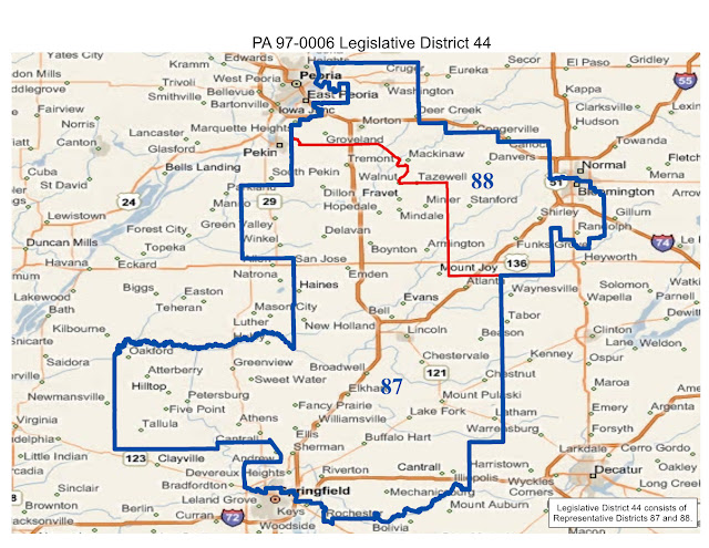
Map of 2012 Illinois Legislative District 44, which includes State Senate District 44 and State Representative Districts 87 and 88:
 |
| Map of realigned Illinois State Senate District 44 and State Representative Districts 87 and 88. |
Map of 2012 Illinois Legislative District 45, which includes State Senate District 45 and State Representative Districts 89 and 90:
 |
| Map of realigned Illinois State Senate District 45 and State Representative Districts 89 and 90. |
Map of 2012 Illinois Legislative District 46, which includes State Senate District 46 and State Representative Districts 91 and 92:
 |
| Map of realigned Illinois State Senate District 46 and State Representative Districts 91 and 92. |
Map of 2012 Illinois Legislative District 47, which includes State Senate District 47 and State Representative Districts 93 and 94:
 |
| Map of realigned Illinois State Senate District 47 and State Representative Districts 93 and 94. |
Map of 2012 Illinois Legislative District 48, which includes State Senate District 48 and State Representative Districts 95 and 96:
 |
| Map of realigned Illinois State Senate District 48 and State Representative Districts 95 and 96. |
Map of 2012 Illinois Legislative District 49, which includes State Senate District 49 and State Representative Districts 97 and 98:
 |
| Map of realigned Illinois State Senate District 49 and State Representative District 97 and 98. |
Map of 2012 Illinois Legislative District 50, which includes State Senate District 50 and State Representative Districts 99 and 100:
 |
| Map of realigned Illinois State Senate District 50 and State Representative Districts 99 and 100. |
Map of 2012 Illinois Legislative District 51, which includes State Senate District 51 and State Representative Districts 101 and 102:
 |
| Map of Illinois realigned State Senate District 51 and State Representative Districts 101 and 102. |
Map of 2012 Illinois Legislative District 52, which includes State Senate District 52 and State Representative Districts 103 and 104:
 |
| Map of realigned Illinois State Senate District 52 and State Representative Districts 103 and 104. |
Map of 2012 Illinois Legislative District 53, which includes State Senate District 53 and State Representative Districts 103 and 104:
 |
| Map of realigned Illinois State Senate District 53 and State Representative Districts 105 and 106. |
Map of 2012 Illinois Legislative District 54, which includes State Senate District 54 and State Representative Districts 105 and 106:
 |
| Map of realigned Illinois State Senate District 54 and State Representative District 107 and 108. |
Map of 2012 Illinois Legislative District 55, which includes State Senate District 55 and State Representative Districts 109 and 110:
 |
| Map of realigned Illinois State Senate District 55 and State Representative Districts 109 and 110. |
Map of 2012 Illinois Legislative District 56, which includes State Senate District 56 and State Representative Districts 111 and 112:
 |
| Map of realigned Illinois State Senate District 56 and State Representative Districts 111 and 112. |
Map of 2012 Illinois Legislative District 57, which includes State Senate District 57 and State Representative Districts 113 and 114:
 |
| Map of realigned Illinois State Senate District 57 and State Representative District 113 and 114 |
Map of 2012 Illinois Legislative District 58, which includes State Senate District 58 and State Representative Districts 115 and 116:
 |
| Map of realigned Illinois State Senate District 58 and State Representative District 115 and 116. |
Map of 2012 Illinois Legislative District 59, which includes State Senate District 59 and State Representative Districts 117 and 118:
 |
| Map of realigned Illinois State Senate District 59 and State Representative Districts 117 and 118. |


